|
|
| (5 intermediate revisions by 4 users not shown) |
| Line 1: |
Line 1: |
| | | | |
| − | Ecosystem based Adaptation(AbE) is defined as the correct use of ecosystem services and biodiversity, as an integral strategy of local producers to face the impacts of climate change (Lhumeau & Cordero, 2012). | + | Ecosystem based Adaptation(AbE) is defined as the correct use of [[Ecosystem Services and Biodiversity|ecosystem services and biodiversity]], as an integral strategy of local producers to [[Portal:Climate Change Adaptation|face the impacts]] of [[Portal:Climate Change Background|climate change]] (Lhumeau & Cordero, 2012). |
| | | | |
| − | In the highlands of Napo, are located three protected areas: Cayambe-Coca National Park, Antisana Ecological Reserve and Sumaco-Napo Galeras National Park. They share a damping area, called Valle del Quijos Conservancy Corridor. High biodiversity and water resources are fundamental for productivity of local farmers (GIZ, 2013). | + | In the highlands of Napo, three protected areas are located: Cayambe-Coca National Park, Antisana Ecological Reserve and Sumaco-Napo Galeras National Park. They share a damping area, called Valle del Quijos Conservancy Corridor. High biodiversity and water resources are fundamental for the productivity of local farmers (GIZ, 2013). |
| | | | |
| | [[File:Geographic distribution of conservation areas in Quijos.jpg|right|750px|alt=Geographic distribution of conservation areas in Quijos.jpg]] | | [[File:Geographic distribution of conservation areas in Quijos.jpg|right|750px|alt=Geographic distribution of conservation areas in Quijos.jpg]] |
| Line 8: |
Line 8: |
| | <br/>Local producers deforest the protective forest during agriculture practices and wood extraction. Only 23% of the sub-basin is used in entropic activities. 10% belongs to rivers and their conservation and 13% is destined to agricultural activities (Efficacitas, 2009). | | <br/>Local producers deforest the protective forest during agriculture practices and wood extraction. Only 23% of the sub-basin is used in entropic activities. 10% belongs to rivers and their conservation and 13% is destined to agricultural activities (Efficacitas, 2009). |
| | | | |
| − | = Conventional agricultural practices Animal husbandry is the main productive activity of local farmers, also is the main cause of habitat defragmentation and low water quality. Inefficient paddock work, intensive land use and excessive use of agrochemical products are some of main causes (MAGAP, 2009). | + | = Conventional agricultural practices Animal husbandry is the main productive activity of local farmers, also is the main cause of habitat defragmentation and low water [[Quality|quality]]. Inefficient paddock work, intensive land use and excessive use of agrochemical products are some of main causes (MAGAP, 2009). |
| | | | |
| | The increasing intensive animal husbandry practices, has caused over-grassing, compaction of soil, less water-retain capacity and wind- and water erosion (Estrada 2009). | | The increasing intensive animal husbandry practices, has caused over-grassing, compaction of soil, less water-retain capacity and wind- and water erosion (Estrada 2009). |
| Line 38: |
Line 38: |
| | [[File:Anual precipitation variation.jpg|500px|alt=Anual precipitation variation.jpg]] | | [[File:Anual precipitation variation.jpg|500px|alt=Anual precipitation variation.jpg]] |
| | | | |
| − | | + | <br/> |
| | | | |
| | = Soil use and management escenarios with SWAT to estimate water and sediment yield = | | = Soil use and management escenarios with SWAT to estimate water and sediment yield = |
| Line 60: |
Line 60: |
| | <br/> | | <br/> |
| | | | |
| − | <span lang="en-us">[[File:Water yield in Quijos sub-basin.jpg|500px|alt=Water yield in Quijos sub-basin.jpg]]</span> | + | <span lang="en-us">[[File:Water yield in Quijos sub-basin.jpg|none|500px|alt=Water yield in Quijos sub-basin.jpg]]</span> |
| | | | |
| | <br/> | | <br/> |
| Line 78: |
Line 78: |
| | At local level, it´s important to decrease land use change. Practices like deforestation increase production of greenhouse gas emissions and reduce carbon sequestration. | | At local level, it´s important to decrease land use change. Practices like deforestation increase production of greenhouse gas emissions and reduce carbon sequestration. |
| | | | |
| − | Local farmers are important in land planning with reforestation and agro-forestry practices, 80% of sub-basin area is under conservation areas, 16228 ha of sub-basin area has 60% slope or more. | + | Local farmers are important in land planning with [[Reforestation|reforestation]] and agro-forestry practices, 80% of sub-basin area is under conservation areas, 16228 ha of sub-basin area has 60% slope or more. |
| | | | |
| | = References = | | = References = |
| Line 99: |
Line 99: |
| | | | |
| | [[Category:Climate_Change]] | | [[Category:Climate_Change]] |
| | + | [[Category:Climate_Change_Adaptation]] |
| | + | [[Category:WikiGardening_-_Structure_&_Article_Name]] |
| | [[Category:Good_Practices]] | | [[Category:Good_Practices]] |
Latest revision as of 08:09, 27 May 2016
Ecosystem based Adaptation(AbE) is defined as the correct use of ecosystem services and biodiversity, as an integral strategy of local producers to face the impacts of climate change (Lhumeau & Cordero, 2012).
In the highlands of Napo, three protected areas are located: Cayambe-Coca National Park, Antisana Ecological Reserve and Sumaco-Napo Galeras National Park. They share a damping area, called Valle del Quijos Conservancy Corridor. High biodiversity and water resources are fundamental for the productivity of local farmers (GIZ, 2013).
Local producers deforest the protective forest during agriculture practices and wood extraction. Only 23% of the sub-basin is used in entropic activities. 10% belongs to rivers and their conservation and 13% is destined to agricultural activities (Efficacitas, 2009).
= Conventional agricultural practices Animal husbandry is the main productive activity of local farmers, also is the main cause of habitat defragmentation and low water quality. Inefficient paddock work, intensive land use and excessive use of agrochemical products are some of main causes (MAGAP, 2009).
The increasing intensive animal husbandry practices, has caused over-grassing, compaction of soil, less water-retain capacity and wind- and water erosion (Estrada 2009).
[edit] Masal movements on local farms
Quijos is vulnerable to masal movals (illustration 2). They cause great loses to local farmer. (Diario El Hoy, 2010).
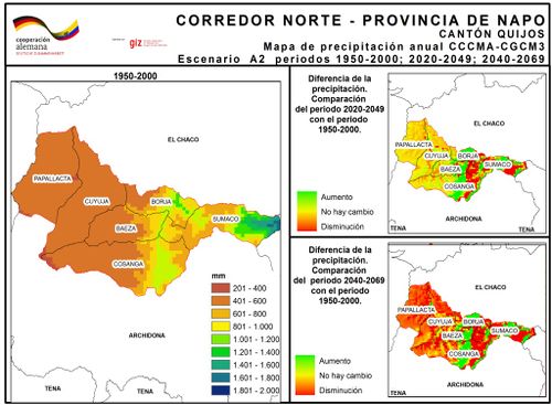
A precipitation climate change scenario (Illustration 3), shown for the year 2069, causes an increase of average precipitation (WorldClim 2010). With instable soils in a mountainous, high precipitations area it is a very high risk to local farmers.

[edit] Soil use and management escenarios with SWAT to estimate water and sediment yield
SWAT (Soil and Water Assessment Tool) it is an instrument to demonstrate how agricultural practices and land management affects water and sediment yield in sub-basin. Sustainable land & agricultural practices are promoted in local farmers to reduce land movals risk.
[edit] Sustainable practices developed in mountainous areas
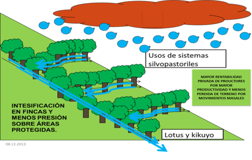
A change in soil and management practices could be a useful key to maintain the ecosystem services. Practices like pasture management, animal charge, rotations, optimized animal feeding practices, no land use change and agro-forestry are opportune in a good practices program.
Agroforestry is an important instrument in conservation areas for human survival. Endemic bushes and trees with high protein content and high digestibility help to increase milk productivity of local farmers. Also a tree provides shadow, which increases 13% of milk production in Jersey cows (WorldClim 2010).

[edit] Escenario 1: Water and Sediment Yield with actual management in climate change
With actual land management, water yield increase in 24% and sediment yield increase in 77% with climate change, mainly in July, August and September. In El Salado micro-basin is located the more increase (Illustration 5). With climate change, the sediment yield in El Salado micro-basin will increase. Deforestation and extensive agriculture increase erosion and masal movals (illustration 6).
[edit] Escenario 2: Water and sediment yield with suastainable land management
If local farmer increase the sustainable land management, increase 16% of water yield and decrease sediment yield in 46%. Sustainable practices like agro-forestry, and reforestation is an effective measure in local farmers.
[edit] Agroforestry is a viable practice in a sustainable sub-basin management
A sustainable basin management with agroforestry, is a practical option for local farmers located in areas with high risk of masal movals. More productivity in plain areas decrease pressure on protected forest and conservation areas.
At local level, it´s important to decrease land use change. Practices like deforestation increase production of greenhouse gas emissions and reduce carbon sequestration.
Local farmers are important in land planning with reforestation and agro-forestry practices, 80% of sub-basin area is under conservation areas, 16228 ha of sub-basin area has 60% slope or more.
[edit] References
A. Lhumeau, D. Cordero (2012). Adaptación basada en Ecosistemas: una respuesta al cambio:
climático. UICN, Quito, Ecuador:
Ministerio de Agricultura, Ganadería, Acuacultura y Pesca (MAGAP), Ecuador: http://www.agricultura.gob.ec/ (Aristizábal, Martínez, & Vélez, 2010:
Diario El Hoy, 2010:
MAGAP, 2009:
Estrada 2009:
Efficacitas, 2009:
WorldClim 2010: